Year level: 5 / 6
Strand: Statistics / Space
Lesson length: 60 mins
In this lesson, students acquire data related to the migration of the osprey. Students describe location and position on a Cartesian plane using paired coordinates. They explore the way latitude and longitude is used to pinpoint a location on Earth.
This lesson is the fourth in a series of six lessons that connect the cross-curriculum priority of Sustainability, Statistics and the Science learning area: Science as a human endeavour. AC9S5H01 , AC9S6H01 and AC9S5H02 , AC9S6H02 .
This lesson was developed in collaboration with Conservation Without Borders. Data and information provided by Tweed Valley Osprey Project.
Learning goals
Learning intention
- We are learning about ways to represent and report on real scientific data.
- We will use the research tasks to develop our understanding of location and position.
Success criteria
By the end of this lesson, students can:
- describe location and position on a Cartesian plane using paired coordinates
- describe the way latitude and longitude are used to pinpoint a location on Earth
- plot points on a grid using simplified latitude and longitude reference points
- interpret location data plotted on a map to identify a mystery bird.
Why are we learning about this?
The work done by research teams helps us to learn more about the natural world. Using the context of contributing to a research team gathering data, we can identify patterns, analyse trends, and observe changes over time. Exploring basic technologies, such as GPS tracking used by scientists, enhances our understanding of data collection and analysis. Additionally, mastering the creation and interpretation of data displays is a crucial skill, as it allows us to communicate information effectively through visual means.
Learning hook 5 mins
- Pose the question, ‘How would scientists discover where birds such as the osprey migrate?’
- Through initial discussion students may mention tracking birds using GPS, scientific observations, community sightings or some form of tagging such as banding.
- Explain that today you will be looking at data that helps scientists determine the position and location of osprey.
Explore 50 mins
Introduction (15mins)
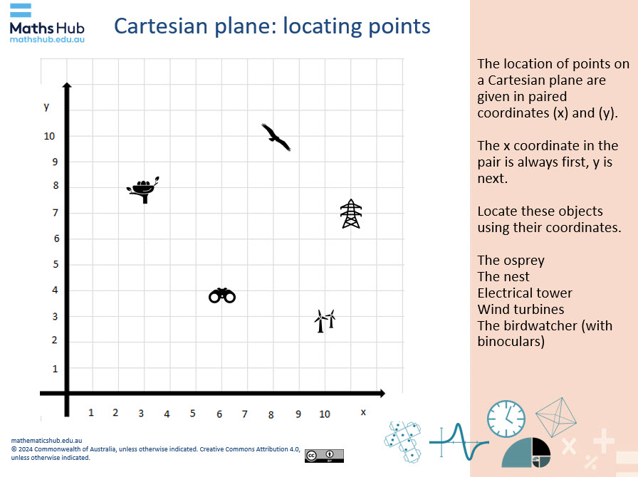
- Explain that one way to describe the location of an object is to use paired coordinates (x) and (y) such as on a Cartesian plane. Make explicit that the x coordinate in the pair is always first, y is next.
Slide 3
- Use slides 3 and 4 to introduce the Cartesian plane. Depending on your student’s familiarity with the concept of plotting coordinates on a Cartesian plane, you may decide to run this section as a class activity. For students familiar with the Cartesian plane, provide them with the Locating points on a Cartesian plane sheet.
Explicit teaching (10mins)
- Learn more about latitude and longitude. Use questioning and feedback as required to assist students to understand that latitude and longitude together pinpoint an object on Earth.
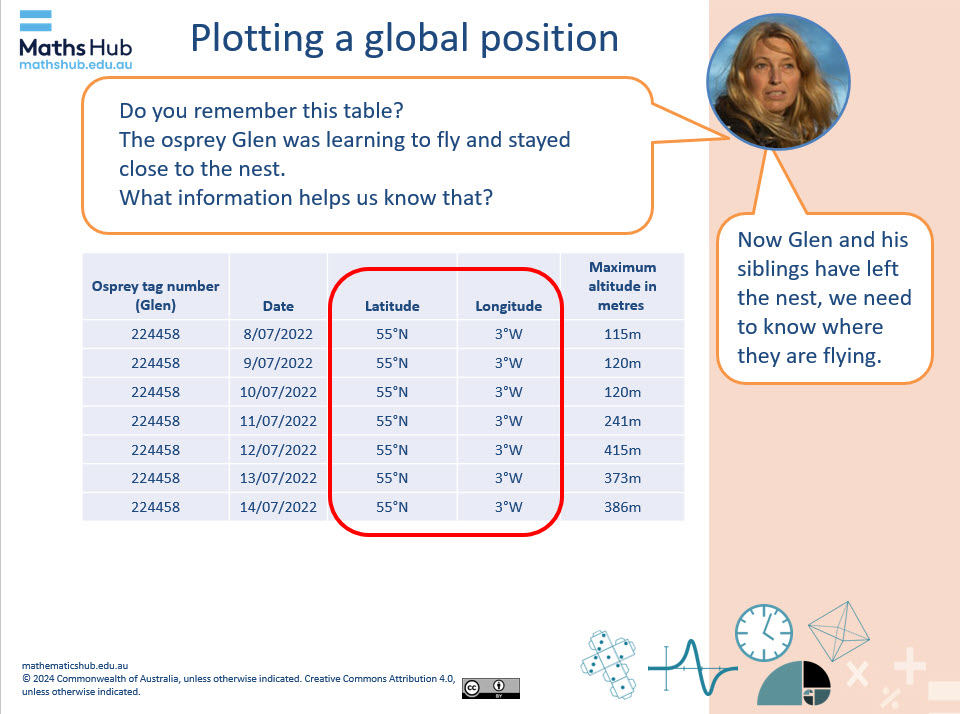
Note, for students at this level we have simplified latitude and longitude numbers in our table to whole numbers (slide 5). More accurate measures are used in data collected by GPS tracking and would typically include date, time and accurate latitude and longitude reference points. For example: 8/07/2022 at a time of 23:45:00 the osprey Glen was at a latitude of 55.242561 and longitude -3.399452 In our data we have used north (N) for latitude and west (W) for longitude to indicate the global position. - Mouse click to reveal an animation (highlighted latitude and longitude columns of data).
Slide 5
- Use slide 6 to explain global position and location in simple terms:
- Latitude is east and west (sideways).
- Longitude is north and south (up and down).
- The equator is the imaginary line that divides the northern and southern hemispheres.
- North is above the equator and south is below the equator.
- Introduce the use of GPS technology to track the osprey (slide 7).
Practical activity (20 min)
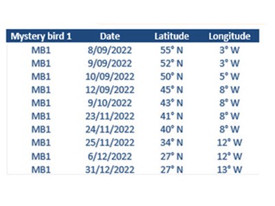
- Introduce the task of plotting paired latitude and longitude reference points from real migration data (slides 8 and 9).
- Distribute the Mystery birds sheet, which contains a table of data and related mapping grid for students plot the pathway of a mystery bird.
- The Location and position data Excel spreadsheet can be used by teachers to demonstrate how latitude and longitude data can be automatically plotted on online mapping software such as Google: My Maps.
Differentiation (support)
- Plot a reduced number of points. Where did your mystery bird start flying? Where did it finish?
Differentiation (enable)
- Where did your mystery bird fly on its migration pathway? How can you represent that on a map?
Differentiation (extend)
- Without plotting the points, what can you predict from the data in the table? How can you work out if you were correct?
Summary and reflection 10 mins
Display slide 11 to summarise the activity and identify the mystery birds.
- Ask students which colour pathway matched their mystery bird. The birds are given names. The birds that corresponded to the data were:
- Glen (ended in Western Sahara, Africa)
- Kirk (ended in Ireland)
- Tweed (ended in Portugal).
- Ask students to use their map showing the pathway and their plotted pathway to identify the mystery bird they chose.